


4.4.2 Case 1: Climate-proof Noordwaard
Course subject(s)
Module 4: Integrated Building with Nature Design
This section provides a synthesis of information on Climate-proof Noordwaard, the first sample case.
Introduction
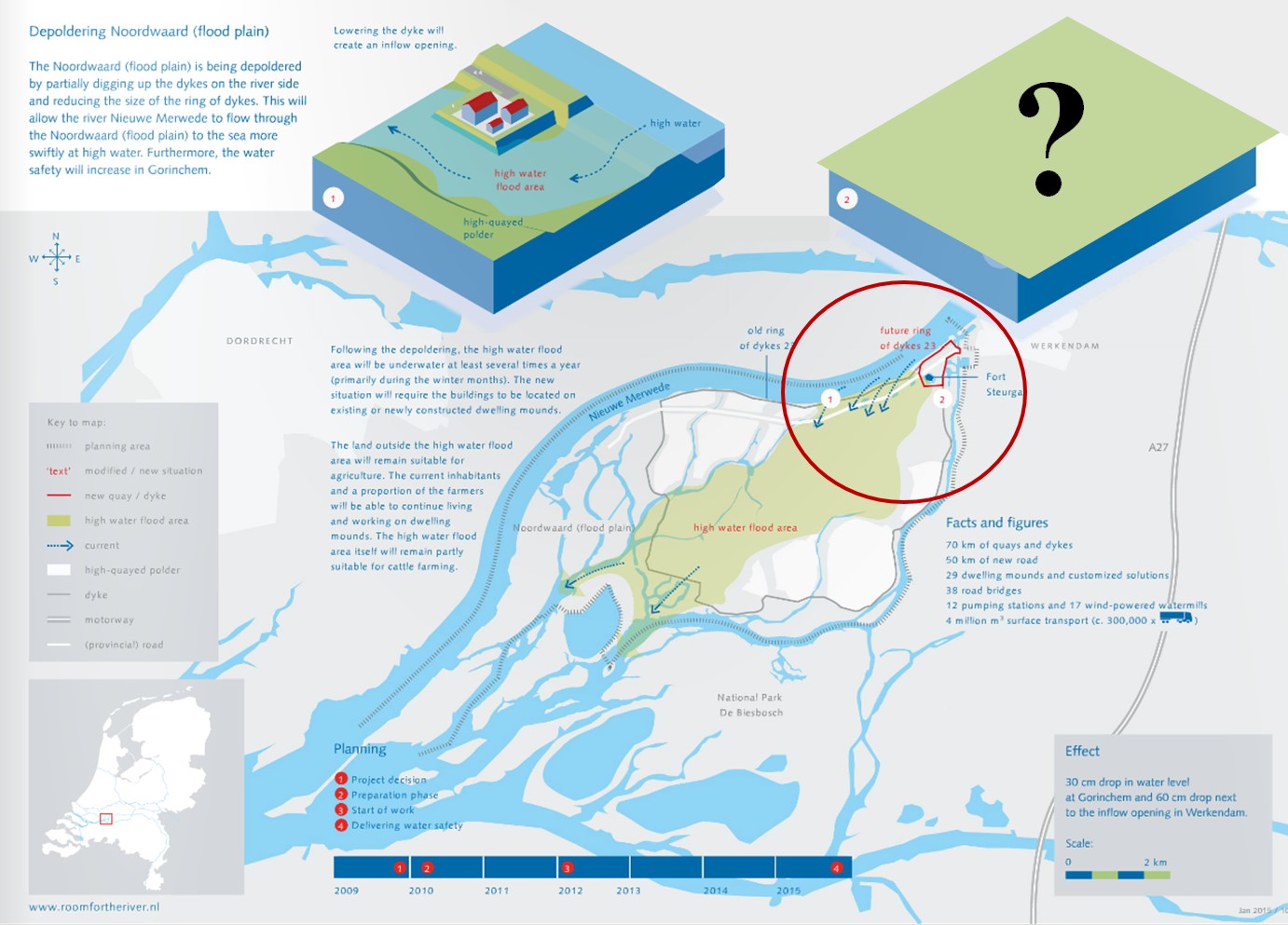
The river Rhine runs through the Netherlands towards the North Sea. During very high discharges, which may occur more frequently in future owing to climate change, the floodwaters needs more space to spread out so as to prevent disastrous downstream flooding. There needs to be more Room for the River! This will be provided for the New Merwede branch of the Rhine by de-poldering the 4450 Ha Noordwaard polder*, which is situated in the South-western part of the Netherlands. De-poldering involves allowing water to stream through and over the Noordwaard polder when the river discharge is very high. By allowing flooding of the land that was previously protected by dikes, the predicted high water levels from river flooding will be reduced by 30 cm at the nearby town of Gorichem.
Nevertheless, within this de-poldered area, there are location(s) that still have to be protected from flooding. For instance, in the North East corner of the Noordwaard polder, a fortress called Fort Steurgat. This fortress has cultural and historical value. This corner is also home to eleven households.
In short, the primary problem owner or client is the Dutch Ministry of Infrastructure and Environment, who is tasked with ensuring that appropriate planning is undertaken to ensure the safety from flooding in the Netherlands. It is they who commission studies to determine the predicted flood levels, and they who then determine the desired reduction in flood level that must be achieved through actions like de-poldering.
* In the Netherlands, a polder is an area of low land that is protected from river or coastal floods by a ring of dikes.
Where is the Noordwaard Polder located?
The Noordwaard Polder, depicted by the purple polygon (area), is situated in the Western part of the Netherlands, close to the cities of Dordrecht and Gorichem. The black polygon (area) in the map represents the North-East corner of the Noordwaard Polder, which is the focus of this case.
Would you like to know more about making Room for the River?
Have a look at the video below.
Source: Ruimte voor de Rivier
Room for the River
Additional knowledge clips on river systems and river interventions
Have a look at the videos below. These videos are part of the MOOC Water and Climate, also from Delft University of Technology. They will provide you with additional knowledge on river systems and river interventions that you can apply to design your own Building with Nature solution.
River Systems
River Interventions

Engineering: Building with Nature by TU Delft OpenCourseWare is licensed under a Creative Commons Attribution-NonCommercial-ShareAlike 4.0 International License.
Based on a work at https://ocw.tudelft.nl/courses/engineering-building-nature/.