3.3.1 Site specificity
Course subject(s)
Module 3. |B| Spatial design

In this week’s video the information a place can hold has been introduced. We guess you already wondered what the environment you see from your window tells you. In order to structure the site analysis, we created a taxonomy by which you can classify your geographic location by selecting options for each section of the taxonomy.

Taxonomy
Section A Climate
Section A generally defines the characteristics and climatic condition of the latitude of your location.
Section B TPI
In section B you indicate the topographic position index (TPI). The TPI is used to define the processes related to the absolute altitude of your location within a catchment. Many physical and biological processes acting on your location are highly dependent of its topographic position. For example, wind exposure, hydrological balance or soil erosion and deposition. The TPI is commonly retrieved with computer models comparing the elevation of a piece of land to the mean elevation of a specified neighborhood around that piece of land. Depending on the scale of the TPI a location is defined as a ridge, slope (upper, middle, flat or lower slope) or valley.
Section C Elevation
Section C defines the relative altitude of a location, the number of meters a location is located above or maybe even below general mean sea level.
Section D Land use / cover
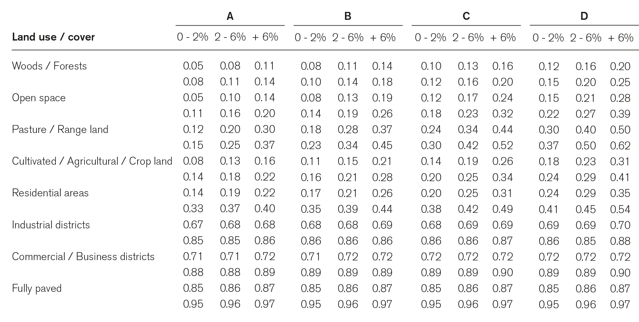
Section D looks into the main land use or land cover of a location. The type of land use or cover of a location influences the quality of the soil below. The quality of the soil, however, is highly site specific.
The land use and cover characteristics this taxonomy looks into are actually the water storage and infiltration capacities. Per category the characteristics can of course still vary depending on the composition of the soil and the slope. Below a short description per category discusses the additional factors which influence the characteristics of the land uses and covers.
Land use / cover
Woods / Forests
For locations mostly covered with woods or forests the runoff is also dependent of the cover of the ground. Ground fully covered with plants or remains of plants allow the highest infiltration of water whereas grazing or burnt remains of plants lower the storage capacity.
Open space (lawn / park / sport field / cemetery)
The runoff from locations mainly consistent of open spaces is dependent of the percentage of grass cover or open soil.
Pasture / Range land
The infiltration capacity of locations with lots of pastures is highly dependent of the exact use of the location. Grass fields providing for hay without grazing for instance have low runoff coefficients whereas grazing increases the percentage of water that runs off.
Cultivated / Agricultural / Crop land
For locations which are mainly used for agricultural purposes the runoff varies with the conservation of the soil. The use of terraces on slopes increases the infiltration capacity.
Residential areas
In residential areas the runoff varies with the density of the houses and the size of the plots. Large plots usually have more green and open space in the shape of gardens.
Industrial districts
For location with an industrial character the permeability depends on the density of industries and the availability of green space in the area.
Commercial / Business districts
Locations with a focus on commerce and business often are the locations with little opportunity for water to naturally infiltrate. The runoff depends on the density of business and the availability of green space.
Fully paved (roads / parking lots / roofs)
In highly urbanized areas the runoff reaches its maximum as all rain falls on surfaces which are closing off the soil. Depending on the availability of green space and roads paved with dirt, gravel or bricks instead of asphalt the runoff can be lowered.
Section E Soil
The last section obviously looks into the type of soil of the location. For soils many categorizations exist. This taxonomy makes use of the four soil groups defined by the United States Department of Agriculture (USDA) focusing on the physical properties of the soil type.
Soil group
A
Soil group A includes deep sands with very little silt and clay and also deep rapidly permeable gravel and has the lowest runoff potential.
B
Soil group B are mostly sandy soils less deep and less aggregated than soil group A and has a moderately low runoff potential but the soil’s infiltration capacity after thorough wetting is above average.
C
Soil group C comprises shallow soils and soils containing considerable clay and colloids and has a moderately high runoff potential but the soils infiltration capacity after saturation is below average.
D
Soil group D has the highest runoff potential and includes mostly clays of high swelling percentage and some shallow soils with nearly impermeable layers near the surface.
Also knowing the average slope of your location, Section D and E together can provide you with the so-called runoff coefficient which tells you the general percentage of water that cannot infiltrate naturally in the ground. The runoff either needs to be discharged with the sewage, increasing the pressure on the sewage system, or increases the water nuisance in the neighboring areas the water runs off to.


Nature Based Metropolitan Solutions by TU Delft OpenCourseWare is licensed under a Creative Commons Attribution-NonCommercial-ShareAlike 4.0 International License.
Based on a work at https://online-learning.tudelft.nl/courses/nature-based-metropolitan-solutions/.


